17 April, 2007

Colima Volcano Ascent

This is the story of seven hikers whose driving passion was to climb the 14,200 foot Nevado de Colima volcano on the border of Jalisco and Colima states in Mexico. There is a volcanology observatory at the 13.000 foot level. My friend Norm Tihor and I had already been escorted off the mountain by the observatory guard and three volcanologists. At that time the army was stationed at the entrance road to the observatory near 12,000 feet just to insure that nobody would be exposed to the frequent eruptions of poisonous gas and ash and potential lava bombs from the active Volcan de Fuego (fire) on the south flank of Nevado. So on this return trip we had arranged to climb up the steep NE backside of the extinct volcano, on the opposite side from the observatory and avoid any contact with the authorities.


On our arrival near our makeshift camp at 11,000 feet, we were all super excited and smiling bravely at our first sight of our objective. From here it looked like the Materhorn. There were four trained rock climbers and four experienced mountain hikers in our group from Ajijic and Guadalajara. From previous experience we knew that it was important to acclimatize ourselves overnight to high elevation. So we happily set up camp and then went on a day hike in the direction of the observatory, leaving our King of the Camp to make dinner.


To our surprise, the normally locked gate on the road to the observatory was open. At this elevation, it was an exhausting trudge, just moving one foot in front of the other. But the reward was well worth the effort when we got our first view of Fuego and the observatory. The buildings were all reinforced concrete, roofs included, with guy wires holding them down to the crater rim. Like a science fiction scene, it was obvious that serious danger could be expected if Fuego blew.


Back in camp, Christopher English had a fire going and foil-wrapped steaks with onions and green peppers ready for baking in hot coals. Were we ever the fortunate ones. Sitting around later with hot chocolate and Baileys and full stomachs we thought about the challenges to face us the next day.


The next morning we were a little chilly but it was an incredible day with amazing clarity. It's usual for Nevado to be capped with clouds by late morning but the conditions were exceptional. Once on the trail, it was shirt sleeve weather even at 14,000 feet. What unbelievable luck!


We quickly left the dirt camp road and headed up towards the beginning of the rock outcrops. The going was easy and soon we arrived at the exposed rock base and our first view across the crater to the observatory. We all took a major rest here because the next part would be up loose volcanic ash.


It was steep and exhausting as it seemed that for every two steps ahead we slipped back one. We learned to step directly on the tuffs of grass to help with our footing and to bring baskets for our hiking poles next time.


As we got out of the ash and onto the solid rock wall, the scenery became awesome. The rock formations caused us to feel like we were in the throat of a volcano. It was very exciting to cautiously follow narrow ledges with sheer drops.


The valley was practically 10,000 feet below us. What an exhilerating feeling. We felt alive!

Double click to enlarge
Finally we arrived on the actual narrow ridge of the crater. There are two stunning high points. We had come along the wall of the lower northern one and now crossed over the bridge between them. In the photo two of us are just starting across, while Norm is reaching up to grasp the top of the high peak.


Double click to enlarge
Below, Larry Laframboise and Christopher are in the final push. It was surreal to be in such an environment. Words really can't describe it. We felt on top of the world!


And there right in front of us as the view opened to the south, was the Volcan de Fuego. What a incredible sight we thought as we looked down on it.


And then it blew!! No fixed photograph can give the sense of a roiling, billowing, actively spewing plume of gases and ashes reaching thousands of feet high in seconds. Our emotions were truly overwhelmed. Then we realized that the gas and ash cloud was coming right at us. Suddenly we thought, "where was that cave we had passed just below us?" Then we noticed that it was going to go right by us, not engulf us. Panic became excitement again.


We were then able to pose in a relaxed manner for our group summit shot. Larry, Gerry, Duncan Poole, Norm, Robert Knapp our climbing guide, Christopher and Rosario Toledo, one enthusiastic lady. We had done it! 14,200 feet. A real adventure.

Double click to enlarge
Down we went, so much easier than ascending. The most difficult part of a climb is often called the crux. This one is called the Jota due to the rock formation being in the shape of a J.


And then the fun began. We had spent time and effort to climb the ash slope. Now we shot the scree, I mean ash. It requires a skating technique as the ash slides underfoot like marbles. Ten minutes to go down what took an hour to ascend. What a thrill!


Each of us stirred up a storm of dust and had a ball. Then back through the trees and down to our camp. After a short rest, we packed up camp and headed for a victory celebration at a local restaurant. This trip had been such a success and an experience beyond our imagination that we hope to do it annually.

07 February, 2007

Mining Country

This Bare Bones Adventure took us on a long loop through silver and gold mining country in Jalisco and Nayarit, high above and east of Puerto Vallarta. We left Lakeside exactly on time at 8:30. Dick Crabtree took Ted Conover, Chad Chadwick and Clive Overton in his Suburu SUV and I, Gerry Green, took Lu Catching, Hank Elliott and Al Borchardt in my Honda CR-V. We drove through Joco and took highway #80 to the turnoff for Ameca (marked San Martin de Hidalgo). Our first break was at the Ameca OXXO about 10:00. Our next stop was at 12:30 just before Mascota at the roadside restaurant La Guera for birrea (goat stew). The gang was happy to be out of the cars as demonstrated by our camaraderie.


After driving across the open plain of Mascota we began climbing into the mountains on the new highway to Puerto Vallarta. Two years ago, while the new highway was being built, we had swerved and bumped along for many miles on a temporary dirt road at the bottom of the canyon, fording many boulder strewn streams. This time was different. We found the paved, but twisty, highway in good condition although it is not a high speed route. Finally we got over the mountains and to the San Sebastian turnoff.

On arriving about 2:30 at 4600 foot high San Sebastian, we moved into our reserved rooms at Hotel el Puente (120 pesos each per night). We noticed tourists all over town using US dollars. The steep rise in prices around town was probably due to the ready access over the newly completed paved highway. This was no longer our remote and secret place! After exploring the village we had an early dinner at a special Mexican restaurant in the northwest corner of town.


Then we all headed for the top of La Bufa in our SUVs, a climb of 4000 feet with an incredible view. Unfortunately near the mountain top, the road was under repair so none of us saw the top, the sunset over the Pacific nor the lights of Puerto Vallarta come on. However, the long uphill walk beyond the blockage was good to do after our substantial dinners. Before turning in, some of us took in a nightcap at another restaurant uphill from our hotel.

Everyone was outside with their packed bags at 8:00 AM ready for breakfast and a quick departure. Unfortunately the cook at the restaurant wasn’t. In Mexico the cook prepares and completes one meal at a time serially so the wait was substantial. But by nine, carrying topographic maps and a GPS, we were on our way north into serious mountain country to find our way through a maze of mining roads.


The route was full of switchbacks and roads carved into towering cliffs. There were numerous places where the edge of the dirt road had collapsed directly down into the canyon a thousand feet below. Often the road was single lane and the infrequent traffic had to back up to hug the edge of the canyon. Fortunately we usually had the inside!

The plan was to find and explore the ruins of the old La Quintera mine. However, what we found was a working, small scale, silver refining plant. It was fascinating to observe the whole process of the ore being ground in a giant rotating drum containing very hard round balls, followed by a process where liquid was added to the ground ore to become a bubbly slurry. I believe the ore impurities were lifted by the bubbles to flow over the side of the huge rectangular tank leaving behind a concentration of silver. The whole process was an engaging sight, especially the young female engineer showing us around.

By 10 AM we were back on the main road and continuing downhill to Santiago de Los Pinos, an area of bare red earth, few trees and considerable erosion. There was an unmapped bypass road (keep right) which added some confusion but soon we were on our way again, our destination being San Felipe de Hijar. What I had expected to take an hour, took two, and Dick’s Subaru was running very low on gas. Driving up one mountain side and down into the next valley, only to repeat the process over and over, used far more gas than expected. There were a couple of shacks here and there but no villages.


Finally we broke out of the high mountains and almost coasted into the dirt village of San Felipe where we were able to buy some bottles of gasoline. Having all taken a mouth full of gasoline at one time or another, we took particular interest in how the young lady used her mouth to get the siphon going. Then off we went to the seemingly only eating place in town, in the far back corner of a store. We ate while Dick and Ted fell asleep on the chesterfield.

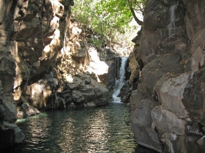
After San Felipe we came across our first paved road, like a super highway leading us down to the hot and humid Ameca River valley at 1470 feet elevation. Then just as unexpectedly we were back into the dirt. However, it wasn’t long before we were at the Balneario el Manto (60 pesos), an intriguing warm springs recreational complex, built into a slot canyon with towering red rock walls above the crystal clear water. With only us there, we played like kids, exploring the canyon and flying down the waterslide. But before long it was time to leave.

As we had spent so much time slowly negotiating through the mountains, we decided to take a short cut home by taking a paved switchback road directly north over a 5000 foot high mountain range and down to the Autopista leading to Guadalajara. Part way up we were surprisingly blocked by a large landslide and so had to return by an alternate route directly east through Amatlan de Canas and Tala to Lakeside, arriving at 8 PM.

It was a very long exploration, packed into just two days. However, the memories of getting to know each other better and sharing the adventure will last much longer.